

Zdjęcia na folii samoprzylepnej autora Peter Hermes Furian
FILTRUJ WYNIKI
Orientacja obrazów: wszystkie
pozioma
pionowa
kwadratowa
Rodzaj obrazów: wszystkie
zdjęcie
ilustracja
wektor
Zastosuj
#755106886
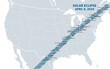 Great American Total Solar Eclipse of April 8, 2024. Political map containing names of cities inside...
#114089218
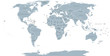 World political map. Detailed map of the world with shorelines, national borders and country names....
#781351286
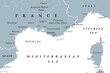 Southern France coastline, gray political map. Southernmost part of France, bordering the...
#514824675
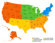
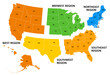 United States, geographic regions, colored political map. Five regions, according to their...
#704863201
 Two bold wavy lines forming a rectangle frame. Decorative and snake-like rectangular border, made by...
#490918514
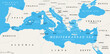
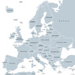 Europe, gray political map. Continent and part of Eurasia, located in the Northern Hemisphere, with...
#567019528
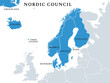 Nordic Council members, political map. Cooperation among the Nordic states Denmark, Finland,...
#514824685
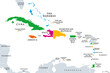 The Caribbean, colored political map. Subregion of the Americas in the Caribbean Sea with its...
#514824649
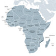 Africa, single countries, gray political map. Largest continent, including Madagascar. With English...
#676073599
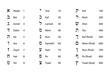 Numeric values of Hebrew letters. Glyphs of the Hebrew alphabet with names and numeration....
#729986558
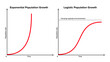 Exponential versus logistic population growth. In reality, initial exponential growth is often not...
#757493930
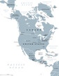 North America, gray political map. Continent bordered by South America, Caribbean Sea, and by the...
#631568539
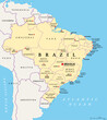
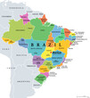 States of Brazil, political map. Differently colored federative units, with their borders and...
#636056856
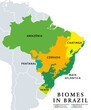 Biomes in Brazil, map of 6 ecosystems with natural vegetation. Amazonia (rainforest), Caatinga...
#709943534
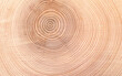 Growth rings of a spruce tree, horizontal cross section, cut through the dried trunk of an European...
#598880205
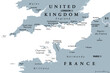 English Channel, gray political map. British Channel, arm of Atlantic Ocean, separates Southern...
#750348010
 Finger Lakes region in New York State, in the United States, political map, with most important...
#747169654
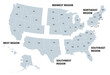 United States, geographic regions, gray political map. Five regions, according to their geographic...
#659100697
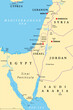 Israel and the Sinai Peninsula, political map. The Southern Levant, an arid geographical and...
#752035418
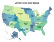 United States major river basins, political map. Nineteen major river basins, highlighted in...
#612340191
 States of Brazil, political map. Federative units with borders and capitals. Subnational entities...
#516171671
 The Mediterranean Sea subdivisions, political map with straits, countries and the Black Sea....
#750348072
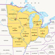 Midwest Region of the United States, political map. Midwestern United States or American Midwest, a...
#579112518
 United States, rivers and lakes, political map. The main stems of the longest rivers, and the...
#514044463
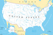
 Geographic regions of the United States, political map. Five regions, according to their geographic...
#751219229
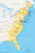 East or Atlantic Coast of the United States, political map. Eastern Seaboard states with coastline...
#512688858
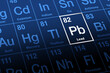 Lead on periodic table. Chemical element with symbol Pb for Latin plumbum, and with atomic number...
#566675851
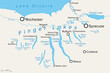
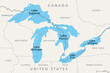 Great Lakes of North America, political map. Lake Superior, Michigan, Huron, Erie and Lake Ontario....
#662268779
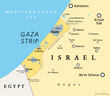 The Gaza Strip and surroundings, political map. Gaza is a self-governing Palestinian territory and...
#552692464
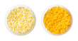 Shredded mozzarella and cheddar cheese, in white bowls. Grated low-moisture mozzarella, and piquant,...
#776084825
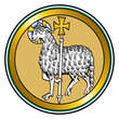 Agnus Dei, the Lamb of God, a medieval visual representation of Jesus as a lamb, carrying a halo and...
#775848785
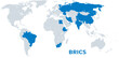 BRICS, with new member states as of 2024, political map. BRICS for Brazil, Russia, India, China and...
dodaj do ulubionych